Monthly Archives: February 2017

Gates open at Lake Tahoe Dam; precipitation record broken in Reno

Reno Gazette-Journal Photo in printed newspaper 2-26-17

The gates at the Lake Tahoe Dam opened on February 22 and are likely to remain open, barring another flood event. Flows from the Lake into the Truckee River went from 50 cubic-feet-per-second (CFS) to 500 CFS at the end of the day last Wednesday. Lake Tahoe’s water surface elevation now stands at 6226.74 feet – 2.36 feet below its maximum elevation of 6229.1.

The Truckee River sees significant flows from Lake Tahoe Dam beginning February 22.

The Truckee River sees significant flows from Lake Tahoe Dam beginning February 22.

That Lake Tahoe will reach its maximum water surface elevation is a “foregone conclusion” according to a quote in the Reno Gazette-Journal on Feb. 26 by Truckee Meadows Water Authority hydrologist, Bill Hauck. Federal Watermaster, Chad Blanchard, controls water releases from Lake Tahoe based on the recently finalized Truckee River Operating Agreement (Dec 2015) and the 1930’s era Court Decree that governs the Truckee River. The Watermaster regulates flows to the river through releases from the numerous reservoirs in the Sierra Nevada west of Reno.

Rainfall record in Reno broken

The 12-month precipitation record for Reno stood since the 1982-83 winter season at 12.72 inches. On February 22, that record was exceeded and now stands at 12.74 inches with 7 months left to go in the water year (Oct 1 – Sep 30). (Check the record here.)

National Weather Service Report 2-23-2017

National Weather Service Report 2-23-2017


With sunny weather and warming temp-eratures forecast for the rest of the week we will have to wait to see if another storm of significance is waiting out there to add to the precipitation total. Given that we have seen many years of drought since 2000, the water we are receiving this year is helping to make up for those deficits. The high water flows have already set the stage for a significant improvement in conditions for the Truckee River, tributaries, and Pyramid Lake.

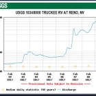
While flows from Lake Tahoe to the Truckee River have increased ten-fold since last week, flows in the Truckee River through Reno show declining flows, indicating that flows from other reservoirs in the Sierra have been reduced. Indications presently are that all area reservoirs will be filled by the snowmelt that will occur over the spring and early summer months.

Truckee River flow at Reno 2-28-17

Truckee River flow at Reno 2-28-17

Truckee River flow near Pyramid Lake.

Reno Gazette-Journal Photo in printed newspaper 2-26-17

Reno Gazette-Journal Photo in printed newspaper 2-26-17

Tahoe rises five inches in seven days; drought shrinks again

Lake Tahoe Water Surface Elevation change from 2-15-17 to 2-22-17.

Lake Tahoe Water Surface Elevation change from 2-15-17 to 2-22-17.

The recent rain storms in Reno and snow and rain in the central Sierra Nevada including Lake Tahoe have raised the Lake’s water surface elevation from 6226.23 to 6226.73 – an additional increase of 5 inches in just 7 days. A significant portion of that rise likely came from rain and snow falling directly on the surface of the Lake. Lake Tahoe occupies 40% of its own watershed. The 5 inch rise is equivalent of 50,933 acre-feet or 16.6 billion gallons of water.The rise is dramatic especially when coupled with the more than 3.5  foot of rise between October 2016 to just before the storms of the past week. Lake Tahoe now stands just 2.37 feet below its maximum water surface elevation of 6229.1 feet (set by court decree). With a current snowpack of more than 200 percent of average, Tahoe seems likely to approach or reach its maximum surface elevation.

Tiny flows from Tahoe into the Truckee River

Truckee River downstream of the Mayberry foot bridge on 2/10/17.

Truckee River downstream of the Mayberry foot bridge on 2/10/17.

The dramatic rise in Tahoe’s water surface elevation hasn’t resulted in significant flows to the Truckee River from Lake Tahoe, however.  In fact, very little water is being released into the Truckee River with flows near Tahoe City, California staying close to 50 cubic-feet-per-second (CFS). Compare this to yesterday’s flow in the Truckee River at Reno of 4,500 CFS. Water in the Truckee River is coming from direct runoff from rain and melting snow into tributary streams entering the Truckee River below Lake Tahoe. Lake Tahoe has a dam (built by the US Bureau of Reclamation over 100 years ago) at Tahoe City that controls the release of water into the Truckee River. Under natural conditions flows from Lake Tahoe would be much higher. It is easy to forget that dams control the amount of flow along the river’s entire course. The biggest diversion on the Truckee River is at Derby Dam between Sparks and Wadsworth.  (Want to know more about tributaries to the Truckee? Click here.)

Pyramid Lake rising finally

Pyramid Lake rose at least 1.27 feet although unofficial reports say the actual rise to date is higher. The last official measurement of the water surface elevation of Pyramid Lake shows the first rise in elevation since 2011. The next measurement of Pyramid Lake’s elevation should be on March 1, 2017 (no measurement occurred in January, e.g.). Yesterday, flows of the Truckee River at Pyramid Lake were just under 7,000 CFS. By this morning’s report on the  Truckee River Operating Agreement website the Truckee River flow at Pyramid Lake’s Nixon Gauge was 6,450 CFS.

Damage at a "dry" stream crossing on SR 445 just north of Pelican Beach at Pyramid Lake

Damage at a “dry” stream crossing on SR 445 just north of Pelican Beach at Pyramid Lake

Pyramid Lake is now accessible on SR 445 although SR 446 between Nixon and Sutcliffe is still closed due to a washout caused by flooding in January 2017. (Click here or the link above for more info).

Drought areas shrinking

In northwest Reno near the University, I recorded approximately 3.75″ of precipitation in the form of mostly rain with slush and snow at the end of the storm. This is a pretty significant amount of rain/snow for just a little over 2 days and may be a record for us at our house. The NOAA California River Forecast Center website reports that since the beginning of the water year on October 1, 2016, Reno has officially received 9.36″ of precipitation – 126 percent of average for an entire year. The Reno precipitation gauge is located at the airport in southeast Truckee Meadows. Precipitation amounts vary widely across the Truckee Meadows.

The Drought Monitor map released on February 14 may change yet again from that shown below when next released. Drought conditions in Nevada and California have consistently shrunk in size and severity as rain pummeled California and western Nevada and snow piled up in higher elevations of the Sierra Nevada Mountains.

Rain returns to Truckee; Pyramid Lake beaches open to fishing

Fisherman at the North Nets on the reopening of Pyramid Lake to fishing since flood damage in early January.

Alum Creek at the Truckee River.

An all-day rain from an atmospheric river storm hit Reno and the Truckee River beginning on early Monday morning (2/20/17) and is continuing as I write this in the early evening. With snow levels not as high as in the previous rainstorm, the rain is forecast to turn to snow preventing any serious flooding on the Truckee River, but creeks and small streams and, of course, ditches could cause local flooding. Snow levels should continue to lower tonight reducing the threat of flooding. The rain, while inconvenient for those impacted by flood issues, is filling the river with water and will likely lead to much improvement for the river’s riparian forest, especially in those areas that have seen significant restoration efforts over the past decade (like Lockwood and 102 Ranch). River flows into the summer should be far greater than those since 2013 and a huge improvement from the serious drought period from 2014-2015.

Damage at a "dry" stream crossing on SR 445 just north of Pelican Beach at Pyramid Lake

Damage at a “dry” stream crossing on SR 445 just north of Pelican Beach at Pyramid Lake

Also, good news was on tap Saturday (2/18/17) when the Pyramid Lake Paiute Tribe opened beaches and boat launches at Pyramid Lake along SR 445 for the first time since the flood damaged roads and beach and boat launch accesses in early January. However, SR 446 between Sutcliffe and Nixon remains closed to all but local traffic due to major damage to the highway north of Popcorn Rock. Fisherman and sightseers took advantage of the opening and many could be seen from the North Nets to Shot-Dog enjoying the respite from rain.

Potential flooding returns to the Truckee

Rain returned to the eastern Sierra and western Nevada this afternoon bringing the possibility of minor to moderate flood stage again on the Truckee River.  Mid-afternoon, the Truckee was running at 7,000 CFS through downtown Reno, but the flow is currently increasing as rain continues and melts low-elevation snow. Temperatures will be falling over the next 24 hours bringing more snow and an end to the rain. Currently, the National Weather Service has the following forecast for the Truckee River.

Flooding on the Truckee River as of early evening Feb. 9.

Truckee River at Wingfield Park Feb 9, 2017

Meanwhile the spillway at Oroville Dam has been severely damaged by high water flows over the spillway and a dam in northeastern Nevada has collapsed flooding the unincorporated town of Montello, NV.

Flood Damage to infrastructure at Pyramid Lake – Pyramid Lake rises

The Pyramid Lake strain of Lahontan Cutthroat Trout has spawned successfully in the Truckee River after an 77 year absence.
Nixon - Sutcliffe highway at Pyramid Lake damage.

Nixon – Sutcliffe highway at Pyramid Lake damage.

Most of us have seen the photos of damage to the roads and infrastructure around Pyramid Lake especially between Sutcliffe and Nixon with the wash out of the highway and loss of water supply to Sutcliffe residents and businesses. Current reporting by the Reno Gazette-Journal says that the Pyramid Lake Paiute Tribe is not allowing non-tribal members entrance to the Lake because of the damage. The estimated date quoted in the newspaper was sometime in April. For those of us who travel frequently to Pyramid to fish, boat, and look at the abundant bird life, it is hard to stay away, but certainly no one wants to interfere with the fastest recovery for the residents and businesses during the infrastructure re-construction period.

Annual Geology Field Tours

Pyramid Lake (from the UNR Geology Field Tour Announcement, 2016)

However, the flood of 2017 had a good effect on the water surface elevation of Pyramid Lake. The surface elevation of Pyramid Lake measured on December 1, 2016 was 3792.16. The latest measurement taken on January 31, 2017 was 3793.43. This rise 1.27 feet of the Lake’s water level is very good news for everyone. This is the first rise of water surface elevation at Pyramid Lake in more than 5 years.

Unfortunately, diversions from the Truckee to the Newlands Project took nearly 700,000 acre-feet of water from the Truckee River over the last 6 years. Had those diversions not occurred, Pyramid Lake would be more than 7 feet higher in elevation providing better habitat for fish and recreation for visitors and residents alike. One example are the boat launch facilities: Popcorn Beach and the Marina at Sutcliffe – both of which have been unusable for several years due to low water levels.) While drought does have an impact, the greatest impact to Pyramid Lake is the Newlands Project which diverts water from the Truckee River to the Carson River.

Since 2000, Pyramid Lake fell 27 feet in elevation exposing vast areas of beach and river bottom at Pyramid Lake and impacting tourism, fishing, boating, and the natural environment that supports numerous birds and the Lahontan Cutthroat Trout and endemic Cui-ui fish essential to the cultural identity of the Pyramid Lake Paiute People.

Truckee Canal ends at Lahontan Reservoir on Carson River

Water from the Truckee River, diverted into the Truckee Canal at Derby Dam, ends in Lahontan Reservoir on the Carson River.