Truckee River Yacht Club founded in 1988 works to protect the Truckee River for all of us – human, fish and wildlife.
Category Archives: Fish and Wildlife
Cui-ui and Lahontan Cutthroat Trout swim the waters of the Truckee River. Originally abundant in Pyramid Lake and dependent on the Truckee for spawning during spring runoff, the Cui-ui fish was a staple of the Pyramid Lake Paiute people. The Cui-ui persists in the lower Truckee and Pyramid and remains on the threatened list because of lower Lake levels and dependency on a lock system to access spawning areas in the River. The Cutthroat Trout, originally found throughout the Truckee River and tributaries and Lake Tahoe and its tributaries, is once again a fishable species in Pyramid Lake due to continued work by the Pyramid Lake Paiute Tribe. Lahontan Cutthroat went extinct in the Truckee, Tahoe, and Pyramid after massive over-fishing, logging, diversions, and the introduction of numerous competing fish from Europe and elsewhere in the US. Lahontan Cutthroat were reintroduced to Pyramid and the Truckee River and are now found in the lower Truckee River and throughout Pyramid Lake. Numerous birds and other wildlife were documented on the Truckee River and river restoration efforts have benefitted many species that depend on the riparian zone of the river and its tributaries.
Join River Justice for a Truckee River Riparian Ecosystem Workshop
Diversity and River Functions are Key
Our work with River Justice continues to help focus on the diversity on the river. This will overall benefit riparian functions, bring improvements to water qualitv and protections to fish habitat.
In this workshop, you will learn about the historical impacts of river projects. You will also understand the threats to LCT and the Kooyooe, Truckee River flow management, data center threats to watershed, bird surveys, solid waste pollution, decreasing cottonwood canopy, bird response to riparian recovery, and river flows influencing cottonwood growth.
The Truckee Meadow Floor Management Authority released two park concepts for a portion of the Rock to McCarran flood protection and river restoration project. One provides for a Nature Park Concept and the other a Sports Complex Concept. We believe that there should be a park which would benefit the community and be completely consistent with the “living river” concept that the community has embraced since the early 2000s. You can check out the link above on the project and the park proposals and read our comments on the park selection to the Flood Managers below:
The Club participated in the “living river” design of the Flood Management Project during its early development. The Rock to McCarran portion was quickly envisioned as a large, flood-able park which was essential to help reduce flood flows and to provide a restored, healthy Truckee River connected to its floodplain. The public benefit of a flood-able, open space park was applauded by everyone at those meetings – now 2 decades behind us. The purchase of the property by the Flood Project was the result of the early flood modeling and public involvement.
Nature Park Concept
The current restoration plan to reconnect the river to its floodplain and provide a broad public benefit still resonates with the community. Certainly, the Club enthusiastically supports the Rock-McCarran Blvd plan to reconnect the Truckee River to its flood plain as depicted on the Rock-McCarran Reach Project Conceptual Recreational Designs. Our support for the park is also strong; however, we believe that the benefit to the public will be best served by the Nature Park Concept.
The Nature Park offers an opportunity to provide a large, Truckee-River-connected Park, close to thousands of residents for the enjoyment of an outstanding natural area that will not be possible in the future.
The Nature Park Concept offers opportunities for enjoyment of the river environment that nearly everyone in the community can benefit from. This concept is less structured, less roaded, less paved, and less crowded space – an increasingly rare commodity in a community where many of the existing parks are crowded with sports playing fields – which while needed – are not appropriate to meet the vision of the “living river” concept that the community supported long ago. [From the original Goals and Objectives: “Promote a living river concept by preserving and enhancing fish and wildlife habitat, water quality, and natural geomorphic characteristics of the river.”] We also note that there could be adjustments to the Nature Park Concept that would likely lower the cost for implementation although we support the Concept as proposed.
The Sports Complex Concept with 10.5 flat playing fields and 4 large and 3 smaller parking lots and a significant amount of paved roadways does little to complement the adjacent restored Truckee River. It seems more than likely that the sports fields and extensive parking will detract from the restored river, be less attractive to the those wishing to see a restored river, and crowds of people at games could result in trash – however unintended – throughout the area.
Sports Complex Concept
There are already plans for 10 large soccer fields at Veterans Parkway and Pembroke Lane which allow for a more compact configuration and access for large gatherings and regional events. This land is also in the 100 year flood area, but would likely be much easier to design and protect than the proposed Sports Complex within theTruckee River’s 100 year floodway. While I understand that the Veterans Parkway-Pembroke Lane sports complex plan is funded for its final design with a $450,000 grant from the City of Reno, funding is not available for the estimated cost of $23 million for the project’s construction. Sports complexes are very expensive -both to build and maintain- and there are questions about how they can be funded.
The Club suggests that the main consideration should remain that the TMFMA flood project objective is to “minimize and mitigate” flood damages to the communities and the best way to do that is with a Nature Park to complement the restored Truckee River. We believe Nature Park Concept is more cost effective, has far fewer hardened surfaces, provides opportunities that are now missing in the Truckee Meadows, and has a wider benefit to its citizens. Finally, we believe that it would also be completely consistent with the original “living river” concept which was a design principal of the flood management project to begin with.
Truckee River Flood from 2005 shown in downtown Reno. The Restoration and Park at Rock and McCarran will help to prevent flooding at the airport, the Reno & Sparks industrial area, and is a critical part of the overall project.Rock & McCarran a key part of the Truckee Meadows Flood Protection Project. Today, it is largely inaccessible from the south with a trail on the north bank and the river is channelized retaining little connection to its flood plain during extreme flood events.
The water year 2022-2023 will certainly be a wet year. Lake Tahoe and the Truckee River basin both are near or above 200% of snow pack water content for this time of the year. The question is, how much of this exceptional snow pack and water will flow downstream to Pyramid Lake?
Lake Tahoe: critical for the Truckee River flows
Truckee River at Wingfield Park
Lake Tahoe is the beginning of the Truckee River. Over the millennia Lake Tahoe was a natural regulating reservoir. Today a dam constructed on the river artificially raises the level of the Lake and controls how much water from the Lake flows into the Truckee River. No water flows into the Truckee River unless the elevation of the water surface elevation of the Lake rises above the outlet’s rim at elevation 6,223 feet. The dam allows the level of the water in Lake Tahoe to rise 6.1 feet higher and store up to 740,000 acre-feet of water. The rise in the Lake’s water surface elevation is most obvious to us when stored water covers up a significant part of beaches such as Sand Harbor State Park or Zephyr Cove. The Federal Water Master determines the amount of water to release into the Truckee River at any given time.
Today (3/29/23) as I write this, only 46 CFS (cubic-feet-per-second) flows out of Lake Tahoe through the gates of the dam and into the Truckee River. Under natural conditions at the Lake’s current water surface elevation of 6,225.4 ft (2.4 feet above its natural rim), much more water would be flowing into the Truckee River. The dam allows farmers and other downstream water users to delay flows into the Truckee River to better suit their needs.
Dams delay and reduce spring flows of the Truckee River
Fish and wildlife throughout the Truckee River basin evolved to take advantage of high spring time river flows that now are controlled by the 6 major dams on the river and its tributaries. Lake Tahoe is the largest storage reservoir on the river. Together, the reservoirs can store nearly 1.1 million acre-feet of water – or nearly two years of the average long-term flow volume of the Truckee River. In early March 2023 about 360,000 acre-feet of water was stored in the 6 reservoirs – most of it in Lake Tahoe. Once snow melt commences, the all the reservoirs will likely be filled as close to their capacity as possible.
From Dry to Wet to Dry to Wet?
Burn near Lake Tahoe in the Carson Range early 2000s
Dry years or below “average” years since 2000 dominated the weather for much of the southwestern USA including California and Nevada. Well above average winters benefitting flows in rivers and storage in Lakes and reservoirs allow us all to breathe a sigh of relief hoping that the “drought is over”. Dry or drought conditions appear to be getting drier and perhaps wet conditions are likewise getting wetter. Extremes may be increasing on both ends. Climate change drives both very likely.
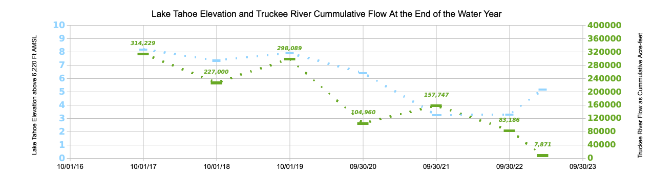
Above average or “wet” (water) years occurred in 2016-17 and 2018-19. Dry years occurred in 2019-20, 2020-21, and 2021-22. The graph shows that up to the middle of March 2023, Lake Tahoe has once again begun to rise. With a significant snowpack now at the end of March, it will likely continue to rise. What isn’t clear is how that will translate into flows for the Truckee River below the dam at Lake Tahoe.
The 5 year drought that proceeded the very wet 2016-17 water year (from October 1 to September 30) left Lake Tahoe nearly a foot below its rim. With significant rain and snow that year Lake Tahoe rapidly rose to near its maximum water surface elevation. Over 314,000 acre-feet of water flowed that year into the Truckee River and the following two years saw an additional 525,000 acre-feet of water. The next 2 years of drought and hot summers emptied Lake Tahoe’s stored water. 2021-22 water year started off wet, but the following January 2022 was the driest on record followed by very dry February and March. Lake Tahoe was quickly drained again.
However, this year the snowpack is nearly double average and colder weather has suppressed the snow melt. As of today, 163 inches of snow stands at Ward Creek on the west side of Lake Tahoe. That snow contains the equivalent of 70 inches of water – just under 6′ of water content. The official “end of winter” measurement of comes in 2 days.
Starting in mid-October 2023, Lake Tahoe fell below its outlet (rim) for just over 2 months. Atmospheric river rain and snowstorms rapidly raised its level by over two feet.
With the approach of April, below average temperatures are expected to persist for the next week or so with more snow also possible over the weekend. Presently, the watershed contains 226% of average snow water equivalent.
Under purely natural conditions all the water in Lake Tahoe above its rim flows into the Truckee River and downstream to Pyramid Lake each year. Pyramid Lake’s water surface elevation stands significantly below its historical level and well below it level in 2000.
How much of this year’s abundant snowpack’s water will flow to Pyramid Lake?
It’s easy to miss Derby Dam on your drive east on I-80. Look to your right when the “Derby Dam” exit sign appears and you’ll see an earthen berm and concrete spillway and some of the dam’s control structures. The dam is off limits to the public.
Locked gates at Derby Dam
But this diversion dam on the Truckee River brought with it a cascade of negative environmental and social effects by not only stopping all fish migration upstream to their spawning grounds but setting in motion a plunging water level at Pyramid Lake and diverting the flows of the Truckee River through a canal to another basin to create new farms in the desert. The Congressional act that created the diversion dam and canal ushered in a era of damming rivers across the west to the detriment of fish and wildlife and, too often, the Native Americans whose livelihoods depended on the rivers and lakes both on and surrounding their reservations. Today, there is the promise of a “fix” with the construction of a fish screen and fish passage at the dam to provide fish access to the Truckee River’s spawning areas from Pyramid Lake all the way to Lake Tahoe.
The Newlands Project: Promise of irrigation ignored Native Americans
Derby Dam (1905) diverts Truckee River Water away from Pyramid Lake into a canal for use in the Newlands Project
The diversion dam was the first of five irrigation projects authorized after passage of legislation sponsored by Nevada Senator Francis Newlands and built by the newly minted Reclamation Service now renamed the Bureau of Reclamation (Bureau). Completed in 1905, the Newlands Project named after the legislation’s namesake, consisted primarily of Derby Dam connected to a 31 mile long diversion canal – the Truckee Canal.†
Together the structures set in motion the dessication of Winnemucca Lake east of Pyramid Lake, an 80 foot drop in water level of Pyramid, the extirpation of the native Lahontan cutthroat trout in Pyramid Lake in the 1940’s, and near extinction of the Cui-ui fish that the Pyramid Lake Paiute People relied on for food for thousands of years and symbolized their cultural identity. Cui-ui are endemic to Pyramid Lake and migrate up the Truckee River to reproduce. The Lahontan cutthroat trout (LCT) became a threatened species and the Cui-ui endangered under the 1973 Endangered Species Act. The Pyramid Lake Paiute Tribe together with others who wanted to see the restoration of the LCT to Pyramid brought another strain of LCT to Pyramid Lake from a population found on the Summit Lake Reservation in northern Nevada. The fish had to be raised in hatcheries on the Pyramid Lake Reservation because they didn’t have access to spawning areas in the Truckee River any longer.
† Lahontan Dam was built later and completed in 1917 and allowed more diversions from the Truckee River for storage.
Truckee River water cascades into Lahontan Reservoir at the end of the Truckee Canal.
More recently the original native strain of Pyramid Lake Lahontan cutthroat trout has been reintroduced into Pyramid Lake. The Cui-ui are successfully spawning using water releases from upstream reservoirs during its spring spawning season. Fish hatcheries operate at Numana and Sutcliffe on the Pyramid Lake Paiute Reservation for the propagation of both species.
Truckee River Operating Agreement and Water Quality Agreement …
Lahontan Cutthroat Trout at Sutcliffe fish hatchery on the Pyramid Lake Paiute Reservation.
… between the Pyramid Lake Paiute Tribe and upstream users have lead to better management of the Truckee River to the benefit of both fish species through improved river flows and water quality. However, Derby Dam and the Truckee Canal remain a blockage to restoring the trout which for millennia migrated the 120 miles from Pyramid Lake up the Truckee River to Lake Tahoe every year to spawn a new generation of fish. The Pyramid Lake Paiute Tribe never gave up on restoring their fishery dependent on the flows of the Truckee River.
Derby Dam on the Truckee River diverts water to Lahontan Valley
Now, the Bureau and the U.S. Fish and Wildlife Service (USFWS) are nearing completion on a nearly $24 million fish-passage project at Derby Dam and the Truckee Canal to help the annual spawning migration of the Lahontan cutthroat trout.
Fish Passage Construction completion slated for Fall 2020
Slated to be completed this fall, constructed fish screens in a “bypass canal longer than a football field” will keep fish from becoming trapped in the canal. An AP article appearing in the Nevada Appealexplained, “The bypass canal will include an 80-foot-wide, 390-foot-long horizontal fish screen — actually a metal plate with slots that pushes water down through the water system while sending the fish and other debris through the side channel”. The article quotes Jody Holzworth, deputy regional director of the USFWS, saying “This day is 100 years in the making. The fish screen will allow this iconic species to travel beyond Derby Dam, from Pyramid lake to their spawning grounds, for the first time in more than a century.”
Construction of fish passage at Derby Dam diversion April 2020. Credit: Farmers Conservation Alliance
Dan Mosley, executive director of Pyramid Lake Fisheries for the PLPT, said the people of the tribe have a long history of fighting for the fish which “are really important in our stories and culture.”
Soon it should be possible for the Lahontan cutthroat trout to pass the diversion dam at Derby and have access to the Truckee River all the way to Lake Tahoe. We wish them a safe journey.
NOAA precipitation forecast probabilities for Dec 17-Feb 18 (click for full size)
The next 3 months, the typical winter here in western Nevada and the Truckee River basin, will determine whether we’ll see a wetter than normal water year – or drier. The forecast? Precipitation this winter currently is a toss-of-the-coin or equal chances for a wet or dry year. Just a little to our south the chances for a dry year increase; to our north the chances for a wet year increase. This forecast looks into our 90 day future from the middle of November 2017.
Whether precipitation prognostications are accurate, we’ll know on February 28, 2018! Western Nevada did get a significant rain last week with some locations in Reno reporting more than an inch of rain. (At our house we had 1.25″!) The Carson Range and the Sierra Nevada received considerably more – especially on the west side of Lake Tahoe. The Lake rose more than 3.5 inches to 6,228.1 ft. Currently, an “atmospheric river” is hitting the Oregon and Washington coast, but missing the Sierra completely. Hopefully, we’ll see storms similar to our recent dump of rain and snow coming soon. The health of the Truckee River, Tahoe, and Pyramid depend on it.
Over the 2-day rain event that started in the late evening of November 15, flows jumped 5-fold in the Truckee River through Reno. Truckee River flows peaked at 3,000 CFS (cubic-feet-per-second) at Pyramid Lake by November 17. As I write, flows of the Truckee through Reno are still more than 1,000 CFS and releases from Lake Tahoe dam into the Truckee River have been increased by the Federal Water Master to more than 1,000 CFS. Flows this winter in the Truckee River will be determined by the amount of precipitation we receive since currently Lake Tahoe and other reservoirs on the Truckee River are nearly full. Lake Tahoe stands today at 85% full, (last year it was essentially empty!) and the next largest reservoir in the Truckee River watershed, Stampede, stands at 90% full. A wetter than average winter means the Truckee River will see benefits for trees, plants, fish and wildlife along its entire length and Pyramid Lake will continue to rise making up for serious declines in water surface elevation suffered during the first 16 years of the century.
NOAA temperature forecast probabilities for Dec 17-Feb 18 (click for full size)
The NOAA 3 month forecast for temperature puts most of California (including all of the Sierra) and nearly all of Nevada likely to be warmer than average. It is no surprise since we’ve seen the consistently warmest temperatures in western Nevada and the Sierra during the past 2 decades. Without serious action on the climate change front, that is very unlikely to reverse itself anytime soon.