Category Archives: Drought

Lake Tahoe: dry to wet to dry to wet, again

Truckee River flows from Lake Tahoe in this 2018 GoogleEarth view.

Extremes likely to continue

The water year 2022-2023 will certainly be a wet year. Lake Tahoe and the Truckee River basin both are near or above 200% of snow pack water content for this time of the year. The question is, how much of this exceptional snow pack and water will flow downstream to Pyramid Lake?

Lake Tahoe: critical for the Truckee River flows

Truckee River at Wingfield Park

Lake Tahoe is the beginning of the Truckee River. Over the millennia Lake Tahoe was a natural regulating reservoir. Today a dam constructed on the river artificially raises the level of the Lake and controls how much water from the Lake flows into the Truckee River. No water flows into the Truckee River unless the elevation of the water surface elevation of the Lake rises above the outlet’s rim at elevation 6,223 feet. The dam allows the level of the water in Lake Tahoe to rise 6.1 feet higher and store up to 740,000 acre-feet of water. The rise in the Lake’s water surface elevation is most obvious to us when stored water covers up a significant part of beaches such as Sand Harbor State Park or Zephyr Cove. The Federal Water Master determines the amount of water to release into the Truckee River at any given time. 

Today (3/29/23) as I write this, only 46 CFS (cubic-feet-per-second) flows out of Lake Tahoe through the gates of the dam and into the Truckee River. Under natural conditions at the Lake’s current water surface elevation of 6,225.4 ft (2.4 feet above its natural rim), much more water would be flowing into the Truckee River. The dam allows farmers and other downstream water users to delay flows into the Truckee River to better suit their needs.

Dams delay and reduce spring flows of the Truckee River

Fish and wildlife throughout the Truckee River basin evolved to take advantage of high spring time river flows that now are controlled by the 6 major dams on the river and its tributaries. Lake Tahoe is the largest storage reservoir on the river. Together, the reservoirs can store nearly 1.1 million acre-feet of water – or nearly two years of the average long-term flow volume of the Truckee River. In early March 2023 about 360,000 acre-feet of water was stored in the 6 reservoirs – most of it in Lake Tahoe. Once snow melt commences, the all the reservoirs will likely be filled as close to their capacity as possible.

From Dry to Wet to Dry to Wet?

Burn in Carson Range above Carson City
Burn near Lake Tahoe in the Carson Range early 2000s

Dry years or below “average” years since 2000 dominated the weather for much of the southwestern USA including California and Nevada. Well above average winters benefitting flows in rivers and storage in Lakes and reservoirs allow us all to breathe a sigh of relief hoping that the “drought is over”. Dry or drought conditions appear to be getting drier and perhaps wet conditions are likewise getting wetter. Extremes may be increasing on both ends. Climate change drives both very likely.

Lake Tahoe Elevation and Truckee River Cumulative Flow at the end of the water year

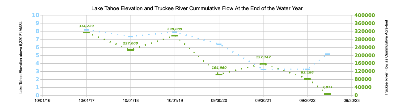
Above average or “wet” (water) years occurred in 2016-17 and 2018-19. Dry years occurred in 2019-20, 2020-21, and 2021-22. The graph shows that up to the middle of March 2023, Lake Tahoe has once again begun to rise. With a significant snowpack now at the end of March, it will likely continue to rise. What isn’t clear is how that will translate into flows for the Truckee River below the dam at Lake Tahoe.

The 5 year drought that proceeded the very wet 2016-17 water year (from October 1 to September 30) left Lake Tahoe nearly a foot below its rim. With significant rain and snow that year Lake Tahoe rapidly rose to near its maximum water surface elevation. Over 314,000 acre-feet of water flowed that year into the Truckee River and the following two years saw an additional 525,000 acre-feet of water. The next 2 years of drought and hot summers emptied Lake Tahoe’s stored water. 2021-22 water year started off wet, but the following January 2022 was the driest on record followed by very dry February and March. Lake Tahoe was quickly drained again.

However, this year the snowpack is nearly double average and colder weather has suppressed the snow melt. As of today, 163 inches of snow stands at Ward Creek on the west side of Lake Tahoe. That snow contains the equivalent of 70 inches of water – just under 6′ of water content. The official “end of winter” measurement of comes in 2 days.

Starting in mid-October 2023, Lake Tahoe fell below its outlet (rim) for just over 2 months. Atmospheric river rain and snowstorms rapidly raised its level by over two feet.

With the approach of April, below average temperatures are expected to persist for the next week or so with more snow also possible over the weekend. Presently, the watershed contains 226% of average snow water equivalent.

Under purely natural conditions all the water in Lake Tahoe above its rim flows into the Truckee River and downstream to Pyramid Lake each year. Pyramid Lake’s water surface elevation stands significantly below its historical level and well below it level in 2000.

How much of this year’s abundant snowpack’s water will flow to Pyramid Lake?

Drought Impacts Persist into Spring 2023

Despite above average snowpack

Reno and environs continue to see above average snow and rain. The rain and snow over the last several months would seem to indicate the drought conditions over the past two years are gone or nearly so. Sure enough drought conditions have lessened (even gone away in some places), but still persist in most of Nevada, a big chunk of northern California and, unexpectedly, most or some portion of each of the other western states.

Copious snowfall in the Sierra Nevada benefits the water outlook for this summer and for the flows of western Nevada rivers – the Truckee, Carson, and Walker. River flows on the Truckee River remained below flood levels, in part, due to the below average temperatures which keep the snowpack from melting and the storage available in the upstream reservoirs.

Lake Tahoe below its rim

Lake Tahoe was 5″ below its rim this past November 30 due to the past 2 years of drought. Since December 1, 2022 Tahoe’s water surface elevation rose 2.7 feet (32.5″). How much will Tahoe’s storage increase once snow melt commences? Spring temperatures and soil conditions and wind will all play a part in determining how much of the water stored in the snowpack flows into the Lake. One thing for sure, cold temperatures experienced this year in Reno and much of the far west are unlike our more recent warm winters (more on this later).

https://droughtmonitor.unl.edu/CurrentMap/StateDroughtMonitor.aspx?West

Drought conditions persist but improve

Drought conditions still stretch across most of Nevada (70%). However, significant improvement since last October resulted from the storms which began hitting the region over the past 5 months. Drought conditions covered 96% of Nevada at the beginning of the water year. Severe (D2) to Exceptional (D4) Drought occurred in 48% of the state. Currently, the highest categories – D3 to D4 – cover only slightly more than 2% and Severe Drought (D2) found in about 14% – a hopeful change for the conditions this spring and summer.

Drought conditions shown on the map occur even though the precipitation since last October is over 100% in most of northern Nevada. If wet conditions continue through the spring and into the beginning of summer, additional improvement may be expected.

Precipitation exceeds the 30 year average

Precipitation for the 2022-2023 Water Year through March 20, 2023

Large snowpacks this year in the Lake Tahoe and Truckee Basin are welcome to help alleviate the drought conditions experienced throughout the west and our region since 2000. Reservoir storage for the Truckee River should improve significantly. However, the western US drought may be more of a more systemic occurrence influenced significantly by Climate Change. Nowhere is this more obvious than on the Colorado River Reservoirs Lake Mead and Lake Powell currently 28% and 23% full, respectively. Conditions for those reservoirs are not expected to improve despite more than 100% snowpack in the Rocky Mountains.

(Watch for a discussion later for how storage affects the overall health of the Truckee River system.)

Tahoe’s water surface elevation elevation over the past year

Flows into the Truckee River at Tahoe City, CA stop once the elevation of Lake Tahoe drops below 6,223 feet – indicated on this graph as “3.00”. Lake Tahoe has a large surface area and around 350,000 acre-feet of water evaporate from its surface each year. Its maximum elevation is set not to exceed 6,229.1 feet.

2023 Sees Big Snow Pack – so far

March came in like a lion with several continuous days of snow. January and February snows in the Carson Range and throughout the Sierra increased an already above-average snowpack for this time of the year to 179% in the Tahoe Basin and 169% in the Truckee Basin.

The welcome snow contrasts with the dry winters for the previous two winters. With climate change making ever hotter summers the Truckee River had low flows, Sierra reservoirs shrunk, and Lake Tahoe fell nearly a half-foot below its rim for 65 days last fall and early winter.

Atmospheric Rivers helped to build the snowpack

Lake Tahoe State Park at Spooner Lake Feb 22, 2023

Rain and then snow powered first by an “atmospheric river” and then a parade of January snow storms pushed the snowpack to over 150% in the Tahoe and Truckee Basin. Storms at the beginning and end of February continued to push the snowpack up and March is continuing the trend. As I write this, it is snowing lightly in Reno. (Another possible atmospheric river arriving in a couple of days could bring rain to lower elevation snowpack with a threat of increasing localized flooding possible.)

From nearly a half foot below its rim, Lake Tahoe today stands over two feet higher. With such a large snowpack yet to melt, Tahoe is set to rise considerably more. Likewise, reservoirs on the Truckee River system have storage available as evidenced by the following table of current levels.

Plenty of storage capacity remains in Truckee River Reservoirs

Reservoir NameStorage in Acre-feetCapacity in Acre-feetCurrent Storage %Remaining Storage in Acre-feetRemaining Capacity (%)
Stampede106,788226,50047.1%119,71252.9%
Prosser9,76729,84032.7%20,07367.3%
Boca18,74840,87045.9%22,12254.1%
Donner3,4529,50036.3%6,04863.7%
Independence (TMWA)13,59717,50077.7%3,90322.3%
Lake Tahoe
† Storage
208,900744,60028.1%535,70071.9%
Total361,2521,068,810 707,558 
March 8, 2023: Truckee River Upstream Storage

Where will this winter snowpack end up? March appears set to add more to the precipitation already received. The next storm system forecast is for rain at lower elevations below 7,000 feet to start.

Lake Tahoe from Mt Rose Highway Feb 22, 2023

The NRCS reports that “[a]s of March 1 the Reno Airport has seen 38.3 inches of snowfall through March 1 which is nearly twice normal for the entire winter.” The Airport has seen at least 4.5″ of snow fall since then.

Still, the total amount of precipitation from the winters of 1982-83 and 2016-17 exceeds this winter’s precipitation – so far.


† By court decree, the dam at Tahoe City, CA at the outlet to the Truckee River can raise the level of Lake Tahoe 6.1 feet to elevation 6,229.1 feet AMSL.

Drought persists: Dry January and February

Dry ground on Peavine Mtn

Deficit of rain and snow continues into March.

Hope for a “jubilant” January, a “fabulous” February, and a “miracle” March fell flat this year. The western US, including much of California and Nevada, faces another drought year. The Drought Monitor map shows the Sierra Nevada in “severe drought” along with all of western Nevada. Worse designations of “extreme” and “exceptional” drought categories are found in portions of 8 of the 9 western states.

Drought Monitor 3-8-2022

Truckee River: low flows ahead for spring and summer

After the summer of 2021’s extreme fires and, in much of the west, unprecedented heat, December’s storms seemed to herald an above average water year in the offing for the Sierra. But a record breaking, dry January and February ended the hope that the 200% snow pack would persist. The ides of March has come and gone. Yet, the Sierra snowpack that supports the Truckee River is just 76 and 68 percent of average in the Truckee River and Tahoe watershed today. Lake Tahoe is just 12″ above its natural rim and the very real prospect of a continuing dry spring mean lower flows into the Truckee River below Tahoe City. The traditional April 1 peak snowpack measurement becomes less relevant as climate change warms temperatures winter and summer. The lack of storms in what should be the Sierra “wet season” stretches our multi-decadal drought for yet a further spring and summer.

Lake Tahoe elevation Jan'20 to Mar'22
As spring runoff approaches Tahoe’s surface elevation stands just 12″ above its rim.

Droughts last longer; CO2 highest in 3.6M years

Scientists studying drought busting rains say the period between rains is getting longer. While rains in the desert southwestern US occurred every 30 days in the 1970s, today the period between rainfall events has grown to 45 days.

The timing between rainfall events stresses plants throughout the region. The decrease in moisture leads to more intense fires and dried up vegetation needed for wildlife and agriculture alike.

The research was led by University of Arizona climate scientist Fangyue Zhang. The reduction in drought busting rainfall across the southwest is consistent with climate models forecasting decreased moisture as the overall atmosphere warms due to human-caused greenhouse gas increases.

“Human activity is driving climate change.” said Colm Sweeney of NOAA’s Global Monitoring Laboratory this Wednesday according to an article in the USA Today which continued: “…the level of carbon dioxide (CO2) in the Earth’s atmosphere is now higher than it has been in at least 3.6 million years.”

Droughts appear to be lasting longer as the active winter pattern of Pacific storms shift north more frequently. This year in California and western Nevada, only one significant storm in January upped the percentage of the meager snowpack. Ultimately, the snowpack topped out around 68% for the Tahoe-Truckee River by April 1, but runoff will be less than 40% of the average due to the extremely dry soils throughout the Sierra and Nevada.

Gulls crowd a recently exposed sandbar in shrinking Washoe Lake.